-40%
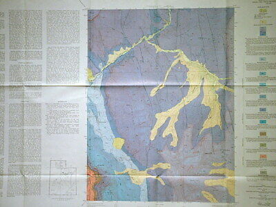
USGS BRIDAL VEIL FALLS UTAH GEOLOGY MAP Full Color Vintage 1972 PROVO RIVER Nice
$ 6.28
- Description
- Size Guide
Description
LAST ONE!!!This is USGS map GQ-998,
Geologic Map of the
Bridal
Veil Falls Quadrangle, Utah
. Published in 1972, this is a great map depicting the complex geology of this gorgeous area. It consists of the original full color 7.5-minute quadrangle map and the original sleeve.
The map depicts the formation in color and details them in descriptive text on the left side of the map. It is very detailed. This area is SE of SLC, east of Utah Lake in the Wasatch Mountains. The Provo river cuts through the NW quarter of the map. Most the map area seems to be rugged mountain country. Cascade Mountain and the Rock Canyon Picnic Area are also on the map. The rocks are folded and faulted, and the cross sections show that nicely. A really nice map for any hiker, camper, geologist or tourist, to help you understand the formations of this beautiful area.
I usually have other Arizona, Utah, and Colorado maps and reports listed, so check my other items.
Expert packing assured. The recent increase in postage rates was pretty big. As a result, Media Mail is now my default shipping method to keep shipping affordable.
Visit my store,
Rockwiler Books and Minerals.
I will continue to add items to my store, so check back frequently.
®
ROCKWILER
